• Welcome to BirdForum, the internet's largest birding community with thousands of members from all over the world. The forums are dedicated to wild birds, birding, binoculars and equipment and all that goes with it.

    Please register for an account to take part in the discussions in the forum, post your pictures in the gallery and more.
ZEISS DTI thermal imaging cameras. For more discoveries at night, and during the day.

Wyre forest (1 Viewer)

Mary

Well-known member
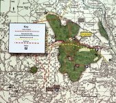
Can anyone help with a parking question, please? Yesterday, we parked at the usual spot at the end of Dry Mill Lane,Bewdley, and walked along Dowles Brook as far as the new sign (see pic-'you are here'). We've not been this far along the track before, and noticed on the mapboard another parking area marked (P) just a bit further on, but too far for us to walk to. I've looked on OS and road maps, but can't see how it's possible to get a car to that spot!! Does anyone know if the tracks are suitably passable for a 'normal' car, and is the turning off the main road easy to find? It would open up more of the woodland for us if we can park there as well. Many thanks.
 

Attachments

  • Wyre Forest board.jpg
    Wyre Forest board.jpg
    201.9 KB · Views: 403
Hi Mary

It would seem odd, but I wonder if there's an error on that map? The OS map of the forest doesn't show a car park there either.

Here's a link to the Wyre Forest Opus article, with map links, if you find out any more could you update the article (or help me to do so) please.

D
 
Hi Delia.

Mary,

It's a while since I walked these routes but from what I remember, the first P is the clearing with room for about 6 cars where the various paths meet.
Walking up the shingle path, that runs parallel and above Dowles (?) Brook eventually brings you to an old railway bridge that crosses over and perpendicular to the shingle path.
The second P is sited at the farm that the bridge points to and which is to the NE of the path. It's not a car park (as far as I know) unless things have changed of late, but it is possible (but not allowed for Joe public) to drive from P to P. You will see Royal Mail and other service vehicles driving up there to get to the farm.
I'll go away and check the name of the brook and farm now...

Dowles Brook is correct and the farm is Lodge Hill Farm (at SO 759766) the farmer is a birder/photographer and has a large feeding station and pop-up hide in his garden. It's a good place to see Yellowhammers, Nuthatches and Redpolls (in season).
 
Last edited:
Aah, maybe I've sussed it out.
There is a road that runs parallel to the road to the first P.
It's the B4194 out of Bewdley. There's a picnic site to the North of the road in Hawkbatch Valleys (an adjoining wood) that has a Car Park (at SO 762776), it's directly 'behind' Lodge Hill Farm but not within the Wyre Forest. I think the P has been transposed incorrectly on your map.
This all said, if your map was a new display in the reserve itself then maybe you can now park at the farm, but it's news to me.
 
Last edited:
Thanks for your replies, Delia and Sy. I have emailed their office, will let you know if I get the answer, Delia. I agree it's probably an error, or only accessible for 4x4s. I can't see our little Fabia managing to plough through that area!
 
If the P is indicative of a new car park, your Fabia will do it without problem Mary, like all the rest of the vehicle that visit the farm.
 
Last edited:
Just an update as I've had a reply. There is an error on the map. It had been muted that parking would be provided at the farm, but, sadly, it's fallen through. When new signs are due, it'll be put right.
 
Warning! This thread is more than 14 years ago old.
It's likely that no further discussion is required, in which case we recommend starting a new thread. If however you feel your response is required you can still do so.

Users who are viewing this thread

Back
Top