BirdsEye just launched a hotspot finding app that shows eBird hotspots for the entire world, providing one tap directions in your favorite nav apps, and links to local bird sightings.
http://www.birdseyebirding.com/other-apps/birdseye-hotspots
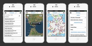
- Get driving, walking and transit directions to any hotspot worldwide in your favorite apps. Hotspots currently works with many of the popular map and navigation apps.
- County listers rejoice! Always know which county you are in and which county your hotspots are in.
- Link directly to the new BirdsEye apps to view local abundance charts of the birds found at each hotspot. (requires BirdsEye NA or any of the other regional BirdsEye apps)
- One tap button to copy the latitude and longitude of a hotspot or your current location to quickly share with others.
- Local weather data - you need to know what the conditions will be when searching for your next birding spot. That spot that is excellent in sunny conditions can be brutal when its stormy while rainy weather can prompt you to head to nearby lakes to look for waterfowl.
- Sunrise and sunset times so you always know how much more daylight you have to twitch that rarity.
- World wide access to eBird hotspots
http://www.birdseyebirding.com/other-apps/birdseye-hotspots