• Welcome to BirdForum, the internet's largest birding community with thousands of members from all over the world. The forums are dedicated to wild birds, birding, binoculars and equipment and all that goes with it.

    Please register for an account to take part in the discussions in the forum, post your pictures in the gallery and more.
ZEISS DTI thermal imaging cameras. For more discoveries at night, and during the day.

Yunnan Birds (1 Viewer)

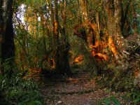
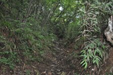
Actually I think I have to make a supplement for Dali and the Cang Shan Park. Today I spend an actually non-birding afternoon with my two daughters on Cang Shan. We followed a friend’s tip and walked a trail from the Gantong Monastery that lies at the very southern point of the mountain park.

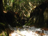
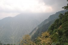
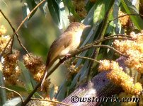
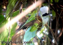
It was afternoon, cold and cloudy and I didn’t even bring my telescope, but during this 3h afternoon walk along a completely empty and more or less even trail there were so many birds that I just couldn’t manage to put down my bins for longer than a minute. And, it didn’t happen that only the bird species were many, but many of these species were represented by a huge number of birds, and they all were so tame…

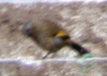
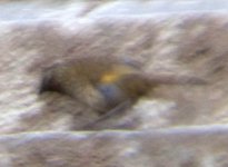
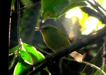
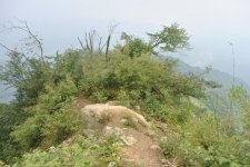
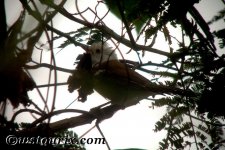
For example there were flocks of 30+ Dark-breasted Rosefinches, 20+ Elegant Buntings, many big flocks of Chestnut-tailed and Blue-winged Minlas, and of course the Rusty-capped and other Fulvettas. I had perfect and repeated views of Assam Laughingthrush, Blyth’s Shrike-babbler or Maroon-backed Accentor. However, the absolute highlight was a group of f i v e adult male Lady Amherst’s Pheasants which were feeding in the open shrub without taken care of us at all – at a distance of 10m!!! Never had that somewhere else!

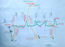
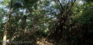
That monastery – the actual starting point of the trail can be reached by car. Ca 4km south of the Dali Old Town there’s a turnoff on the right hand side that leads up the mountain to one of the many Cang Shan cable cars. From here just follow the trail towards the Qingbi Xi Gorge.
 
Delighted to hear my old report delivered some birds Roland

Your update on Dali / Cang Shan is interesting indeed - still never seen a male Lady A's despite several trips to Dali and a few walks along the contour path. . . . one day.On my first visit here in 1991 I had my first ever Great Black-headed Gull flying round the square reservoir in the centre of the town.

I also want to add one more good bird - Rufous-tailed Moupinia is in the gorges directly uphill from the old town.

Cheers
Mike
 
Wow, that really sounds like my idea of a perfect birding trip. Especially seeing the pheasants at such a close range!

Ed
 
A few days back I passed Dali again and couldn’t resist walking the monastery trail once more – hoping for a good picture of Lady Amherst’s Pheasant this time. And indeed the pheasants were still at the same spot (this time only three males). But it was the third day of the Chinese New Year and people started to slowly crowd the mountain. Unfortunately every time the pheasant decided to pose in a rather open spot, a group of shouting people approached and it searched for cover again. After ten or so times I eventually gave up.
I decided to walk a bit further along the stream (named Qingbi Xi) and as a solace encountered still a lot of good birds: Brown Dipper, Little and Slaty-backed Forktail, Blue Whistling Thrush (ssp eugenei) and to my very surprise an Alpine Accentor – the lowest record for me in China (at approx 2300m). Also Laughingthrushes were not scarce: three Assam’s, two Elliot’s, four Black-faced and three Scaly Laughers showed all well and without rush.
 
Delighted to hear my old report delivered some birds Roland

Thanks again for your reports, Mike!

I also want to add one more good bird - Rufous-tailed Moupinia is in the gorges directly uphill from the old town.

Was looking for the Moupinia, but couldn't find one this time. However they are not very common anyway I guess, and let them just be at another spot a bit away from where you are that moment, than you just miss them....
 
This morning again at Cang Shan in Dali (a good place for a layover indeed): Apart from the previously mentioned birds I have to add a pair of Sharp's Rosefinch and two Blue-winged Laughingthrushes.

My desperate attempt to find a trace of Yunnan and/or Giant Nuthatch on Cang Shan still remained unrewarded. My friend Zhao Chao, a Top Birder from Beijing who works in Dali, confirmed the absence of the both nuthatches on Cang Shan. Still surprising, because the habitat seems to fit perfectly: dominantly Yunnan Pine.

Attached is something that should resemble an image of the Blue-winged Laughingthrush from this morning: it was quite dark in the gorge just after sunrise and I couldn't find a position to stabilize the camera - i am really sorry. But nevertheless one can see the blue wing panels, the darker tail and the light rufous taint on the upper tail, features that distinguishes it from Scaly Laughingthrush (which it was together with this morning and which looked slightly different).
 

Attachments

  • blue-winged Laughingthrush.jpg
    blue-winged Laughingthrush.jpg
    89.5 KB · Views: 51
  • blue-winged Laughingthrush 2.jpg
    blue-winged Laughingthrush 2.jpg
    102.7 KB · Views: 38
Cang Shan Bird List

Perhaps it’s time to summarize the birds seen on Cang Shan during February 2016.
Lady Amherst’s Pheasant
Grey-capped Pygmy Woodpecker
Bar-tailed Treecreeper
Black-shouldered Kite
Comon Buzzard (japonicus)
Long-tailed Shrike
Red-billed Blue Magpie
Yellow-bellied Fantail
White-throated Fantail
Little Forktail
Slaty-backed Forktail
Brown Dipper
Blue Whistling Thrush (eugenei)
Himalayan Bluetail
White-capped Water Redstart
Blue-fronted Redstart
Yellow-browed Tit
Green-backed Tit
Black-browed Tit
Asian House Martin
Crested Finchbill
Sooty-headed Bulbul
Brown-breasted Bulbul
Ashy-throated Warbler
Buff-barred Warbler
Pallas’ Leaf Warbler
Brown-flanked Bushwarbler
Scaly Laughingthrush
Elliot’s Laughingthrush
Black-faced Laughingthrush
Blue-winged Laughingthrush
Assam’s Laughingthrush
Streak-breasted Scimitar Babbler
Black-streaked Scimitar Babbler
Wren
Blue-winged Minla
Chestnut-tailed Minla
Red-billed Leiothrix
Blyth’s Shrike-babbler
Green Shrike-babbler
Rusty-capped Fulvetta
White-browed Fulvetta
Spectacled Fulvetta
Black-headed Sibia
Rufous-vented Yuhina
Maroon-backed Accentor
Alpine Accentor
Olive-backed Pipit
Dark-breasted Rosefinch
Sharp’s Rosefinch
Vinaceous Rosefinch
Elegant (Yellow-throated) Bunting
Little Bunting
 

Attachments

  • tourist_map_cang_shan.jpg
    tourist_map_cang_shan.jpg
    166 KB · Views: 61
Now I think it’s time to get a little bit deeper into the GAOLIGONG SHAN birding business. On its northern tip the famous Gaoligng Mountain Range emerges from the Tibetan Plateau, runs over almost 400km southwards in one straight slim line, while partly bordering Myanmar, and eventually fades out into the hilly Dehong Prefecture in Western Yunnan. Due to its high biodiversity, the entire range actually is considered a national nature reserve. However, this doesn’t stop locals from poaching, illegal logging and – especially on its southern east face (along the Nujiang River) – from converting precious forest into coffee plantations.

Its most famous birding spot so far is Baihualing ca. 35km north of the Township Lujiangba (expressway connection), but there are quite a few more places to go, if independent transport available:
There is for instance the Pianma Road ca. 30km north of Liuku Town. It crosses the mountain range and ends in the border town Pianma. Ca. 100km to the South there is Baihualing, and again a bit further south, a very old cobble stone road crosses from Lujiangba to Tengchong, namely the Old S317. And last but not least there’s the most southern tip, by some people called Xiao Hei Shan. This place is accessible through the recently most common road westwards: the newer version of the S317 (to make the confusion perfect). However, this road again is not important anymore, for there’s the brand new expressway G56 that drills its way through the mountain a few hundred meters lower.

Most charismatic birds associated with Gaoligong Shan, just to name a few, are: Sclater’s Monal, Hume’s Pheasant, Ward’s Trogon, Slender-billed Scimbab, Blue-winged Laughingthrush, Streak-throated Barwing, Cachar Wedge-billed Wren Babbler, Fire-tailed Myzornis, Golden-naped Finch, and many more.

Baihualing is easily accessible and there’s decent accommodation available in the near village. Assistance can be arranged by the forestry bureau at site or in Baoshan, if you want to get access through them. However, practically there is yet no permission or entry ticket required and you can just drive up the road to where the forest begins and start birding. (Actually there are a few big Banyan trees on the way up which are worth having a quick stopover – on the way down or for an afternoon break).

Here is some info on recent changes in Baihualing: The forest is shrinking due to expanding coffee farming and I can’t see an end, especially because the Chinese demand on coffee has just started and is increasing rapidly. The good news is that locals have stopped shooting at birds here and instead have set up puddles as feeding stations and blinds in the forest in order to attract both birds and paying bird photographers. Latter are numerous, tendency growing. However, apart from resulting problems with limited parking spots, this doesn’t actually affect bird-watching seriously. It’s just that you spend a bloody whole day with looking for a rarity such as the legendary Slender-billed Scimitar Babbler, and then in the evening there’s a bunch of photographers who hold their camera under your nose and present a crisp and frame-filling picture of this bird taken by the feeding puddle…

A very helpful sketch map of Baihualing is available at this link:
http://www.surfbirds.com/trip_report.php?id=757
http://www.surfbirds.com/gallery/display.php?gallery=gallery27&start=110#photo_id_95106
or in Jocko Hammar’s trip report:
http://www.cloudbirders.com/tripreport/repository/HAMMAR_China_0405_2014.pdf

The Jiu Gaizi Ridge Clearing is one of the best birding places I have ever experienced in China: birds around the clock, especially when the sweet Leucosceptrum canum bushes are flowering: Scaly, Red-tailed, Streaked etc. Laughingthrushes, Fire-tailed Sunbird, Beautiful, Grey & Black-headed Sibias, 5 species of Yuhinas, and so on. Furthermore, each trail or better each section of the trails actually is worth a whole day exploration. So design your schedule generously enough!

Sometimes the forest trails appear empty compared to the busy Lao Gaizi Clearing, but after all this is where you can find Hume’s Pheasant, Wren-babblers, Trogons, Woodpeckers, Fulvettas, Thrushes etc.

The trail up to the main pass takes about five hours hiking one way, that’s where Sclater’s Monal is supposed to stick its head out of the dense bamboo carpet by daybreak. Many people stay overnight on the pass for the pheasant, but you have to prearrange porters and equipment (tents, food, etc) in advance, if you don’t want to carry all that stuff on your own.

Theoretically, there should be two easier accessible places for Sclater’s Monal: the two passes of the Pianma Road and the Old 317 respectively, for they almost reach the required altitude. However, it still has to be proved that the bird is there. I have failed two times so far…

Most birders visit Gaoligong Shan in winter or early spring, due to dry season. It saves you from considering rain, wet trails, leeches etc. But, even if in winter birds are numerous and active all throughout the day, planning a visit during breeding season might be still better for certain bird species, i.e. the shy ones, for they can be localized easier when singing, as Jocko’s trip report (see above) proves.
Additionally, the high pass can be very cold, windy and even snowy in winter.

Attached is a picture from the Lao Gaizi (or Lao Jiezi = Old Street) at sunrise
 

Attachments

  • Gaoligong Mountain Range.jpg
    Gaoligong Mountain Range.jpg
    240.9 KB · Views: 55
Last edited:
Here are two more pictures from the trail that leads up to the pass. The picture in the sunrise is not far from the Lao Gaizi Clearing.
The snowy one is ca. 2h higher up after crossing a stream. A little bit before the trail forms this slightly steep hollow way, on a wet, grassy clearing there's Hume's Pheasant.
 

Attachments

  • gaoligong baihualing trail sunrise.jpg
    gaoligong baihualing trail sunrise.jpg
    202.8 KB · Views: 54
  • gaoligong baihualing trail.jpg
    gaoligong baihualing trail.jpg
    196.9 KB · Views: 53
Last edited:
The Pianma Road

The Pianma Road

Ca. 30km north of the Town Liuku (now also called Nujiang as it has reached capital status of Nujiang Prefecture), there is the turnoff towards west, in the direction to Myanmar. It’s not easy to miss, and from there actually you just have to follow the one single road. The eastern side seems less interesting, since large scale logging and farming has had a huge impact. However, at approx. 2km before the pass, where the road traverses a steeper, rocky section, in the valley above the protection station, Gold-naped Finch has been sighted.

The pass is all bamboo covered, but there is a small trail that leads along the ridge. I found it very difficult to move through the bamboo that partly has been overgrowing the path. Perhaps this might be a bonus for the presence of Lophophorus sclateri.

The following two bends behind the pass were not very exciting; maybe because of the strong wind, all birds were hiding in the cover of the dense bamboo. I guess in better weather or later in the year this section can be quite rewarding (I stayed here during Chinese New Year).

Nevertheless, when entering the forest it starts to become interesting. The best section probably is from Km66 to Km74: here the road winds through some nice forest (with unfortunately still a lot of evidence of illegal logging; see picture attached). Various Laughingthrush and Sibia species, Barwings (Streak-throated and Rusty-fronted), Black-faced Warbler and Fire-tailed Myzornis were fairly common. Slender-billed Scimitar Babbler and a very likely Black-browed Parrotbill were heard several times.

The first picture shows the sophisticated way of illegal logging: taking the timber without cutting down the tree.
The second a blurry Fire-tailed Myzornis – unfortunately the best picture I could make with my pocket camera.
 

Attachments

  • carpenters tree.jpg
    carpenters tree.jpg
    240.9 KB · Views: 60
  • fire-tailed_myzornis.jpg
    fire-tailed_myzornis.jpg
    112.1 KB · Views: 52
Hi Roland, "Yunnan Province" is a great idea for a thread, and thanks for all the up-to-date stuff mentioned so far.

The Pianma Road is a fine site, and here are some historical observations I wrote about this fascinating area. here:

Last September a group of HK and Chinese birders saw a female Sclater's Monal near the pass (KM 59).
 
The trail looks stunning, especially if you had it pretty much to yourself.

It’s interesting to me that in the second picture looks 'sunken'. I was surprised that a difficult and faint mountain path I climbed last summer (in Sichuan) joined a similarly sunken path perched on a ridgetop (see pic). The sides of the ridge were exceedingly steep, and it was in the middle of nowhere, so I was taken aback when I finally ascended the ridge to find a well trodden path running along it. Perhaps its ‘sunkeness’ is a result of rainfall runoff eroding a minor path, but I imagined it forming due to many centuries’ worth of people tramping along it to hunt, gather medicines, cut timber etc. Obviously I know that the resources of the forests have long been a major asset for locals, but it made me think that some of the more remote places I had previously assumed too inaccessible to have been impacted by humans actually have long histories of utilisation. Still it felt great to be surrounded by rich forest with nobody around. Birding was nothing compared to your Yunnan trip however...

Ed
 

Attachments

  • DSC_0353.jpg
    DSC_0353.jpg
    449.7 KB · Views: 41
The trail that crosses from Baihualing to Tengchong is an old trading road. The Laogaizi clearing has been one of the trading posts, probably with buildings (noodle shops, farrier stalls, etc.). That explains why this trail is sunken.

In other places (e.g. Sichuan) I also think that sunken trails have developed by yearly rain washing away the soil which has been continuously exposed by people or animals treading on. Due to the soil is quite heavy and contains much clay, it has been washed away only on the path's surface without harming the edges.

Attached are two calls from this place:
Fire-tailed Sunbird is quite common on the Laogaizi Clearing
Black-eared Shrike-babbler was recorded a bit further up the trail
 

Attachments

  • fire-tailed_sunbird--call--gaoligong.090215.rz.mp3
    685.8 KB · Views: 21
  • black-eared_shrike-babbler--baihualing.230215.rz.mp3
    230.6 KB · Views: 17
Yes, your trail has a nice feeling of history to it. Given how torrential rainfall can be during the summer monsoon I can well believe that my ridgetop path has largely been cut by channelling runoff.

I enjoyed the bird calls and the wider sounds of the trail.

Ed
 
I don't know what the trail you saw on the ridge top was like, but we once walked a sunken trail in the US, which like Roland describes was sunken from decades or centuries of people walking on it. (See here.) I wonder if the trail Roland is describing might be part of the old "Tea Horse Road."
 
Hi Gretchen,

I like the look of that Natchez Trace, like Roland’s trail it has a nice feel of history to it.

These pictures show where landslides have exposed my sunken path. You can see it isn’t easy going and as it only leads to higher ridges and pinnacles I don’t think it’s an old trade route. I suspect its existence is down to a long history of locals making their way up to access resources high up on the mountain.

I can imagine sections of Tea Horse trails that haven’t been upgraded with roads make great hiking nowadays!

Anyway, apologies Roland, I'm not really familiar with forum etiquette but I think going off topic is a no no so sorry about that.

Ed
 

Attachments

  • DSC_0335.jpg
    DSC_0335.jpg
    206.5 KB · Views: 38
  • DSC_0395.jpg
    DSC_0395.jpg
    362.2 KB · Views: 48
Anyway, apologies Roland, I'm not really familiar with forum etiquette but I think going off topic is a no no so sorry about that.

Not at all. The pictures of the trail remind me on Jiufeng Shan. Are they from there?

And I think this trail across Gaoligong Shan at Baihualing often is referred to as part of the Southern Silk Road, which of course could also have served as a part of the Tea Horse Road - after all southern Yunnan also has a long tea producing tradition.
 
Right area, it’s 20km to the SW, west of the village Xiaoyundong, which you pass through on the way to Jiufeng Shan. The part I climbed was far from as nice as Jiufeng Shan, but it’s a little more convenient to get to. If you are interested PM me and I’ll tell you how to find the path. I didn't get too high a few peals of thunder that sounded like they were just above my head sent me scurrying quickly back down. When I'm back in Sichuan this summer I plan to return, early in the day so I’ve plenty of time to explore further.

Bird-wise I think I saw nightjar lowdown on the mountain slope. Three birds exploded up from vegetation regenerating on a landslide, almost under my feet, flew around me making strange calls, and then settled down on the ground a just few meters away on an unstable bit of slope (I couldn’t relocate them despite the proximity). It happened so quickly and unexpectedly I didn’t get a good look, but it sounds like what I’ve heard of nightjar. One definite new bird for me was a family of grey bushchat.

So Roland, I look forward to your next post on birding in Yunnan. Will be interesting to continue to get a feel for the extent to which Yunnanese birds are the same or different from Sichuan. I've also noticed some of the threats to the environment are different e.g. the coffee plantations and possibly that very targeted logging you came across.

Ed
 
Another important area in Yunnan, from the perspective of a Chinese bird list, as well as considering that many bird species so far are quite difficult to access from the Burmese side is the Yingjiang/Nabang area at the most western border of Yunnan Province. Yingjiang is quite a huge county and comprises five birding areas:

1. Lianghe Town: Between Tengchong and Yingjiang County Town there’s a long stripe of agricultural land along the road with many paddy fields, lotus ponds and water channels. Best place so far were the few kilometers before one reaches Lianghe Town (close to the “national security checkpoint”). Many waders, water birds starlings and raptors stay here over winter.

2. Nabang: Tongbi Guan Forest and Banyan King Tree are different parts of a huge forest reserve, which has to be passed on the way downhill towards Nabang Town.

3. Nabang: Old Xima Trail begins a few KM north of Nabang Town. See Google Earth file attached.

4. Nabang: Riverside 10km before reaching Nabang Border Town. See Google Earth file attached.

5. Hongbeng He(洪崩河) is actually also part of Tongbi Guan Reserve but has to be approached from a completely different direction. See Google Earth file attached.

Birds and a more description of each site will follow soon.
 

Attachments

  • Riverside Nabang.kmz
    718 bytes · Views: 64
  • Start Point of Xima Trail.kmz
    722 bytes · Views: 45
  • Hongbeng He Powerplant.kmz
    705 bytes · Views: 101
TONGBI GUAN: If you take a look on a map of the Yingjiang area, you will find the name Tongbi Guan (=Copper Wall Pass) spread over quite a huge area. Indeed, the forested area seems to stretch from the Hongbeng River in the south along the Myanmar Border to Houqiao Town in the North, with a total length of more than 120km.
However many of this area is plantation or has been logged recently, but there are still considerable spots of good and old forest left, even if increasingly managed. Therefore, the actual Tongbi Guan Nature Reserve obviously consists of quite a few fragmented areas which are more or less protected or, at least theoretically, under protection of the forestry bureau.

The Old Banyan King is an easily accessible birding spot on the downhill section of the road towards Nabang Town and is less than half an hour away from this interesting border town. There is a signboard that announces the turn-off. It has been stated in so many reports that I don’t think I need to tell too much about it in this post.
The only thing I find worth mentioning is that birding activities in this place might have a positive impact on the environment, for it might slow down forest exploitation through raising environmental awareness amongst locals. So keep on visiting this place!
Unfortunately, due to illegal logging, big trees and canopy birds seem to be on the decline and vines and shrub birds slowly take over. White-hooded Babbler, both Red-billed and Coral-billed Scimitar-babblers or Black-browed Parrotbill were easy to see in the past years. Other marvelous birds such as Emerald Dove, White-crested Laughingthrush, Silver-eared Mesia and Flavescent and White-throated Bulbuls belong to the more common species one can find here.

The Old Xima Trail begins a few KM north of Nabang Town. Big areas at the bottom of the forested range have converted to banana and monoculture tree plantations recently. Unfortunately and even worse, the formerly well forested Burmese side across the river experiences heavy chainsaw impact. Due to harsher restrictions on Chinese forest (which is good of course), the greed of business makers puts hand on the Burmese side of the forest now. I guess this happens all over Myanmar, but I can only confirm logging activities in bordering forest while standing on the Chinese side. I also dare to conclude that this is one of the main reasons why people don’t see any Hornbills there anymore (including me).
The trail itself seems abandoned and gives a nice, consistent and undisturbed birding experience. I could hardly see traces of logging or other usage both times I was there, although the forest itself seems to be shrinking. Bird flocks sometimes were quite big but lacked a bit of variety. Missing hornbills, raptors, or other typical tropical birds such as broadbills, cochoas, pigeons or sibias made this trail a bit disappointing. Highlight for me was a pair of Kalij Pheasants, a heard pair of Spot-bellied Eagle Owls, a Barred Cockoo Dove and a single Pale-headed Woodpecker.
Here’s a list of Birds seen in February 2015 and 2016:
Kalij Pheasant (2), Pale-headed Woodpecker (1), Red-headed Trogon (1), Blue-throated Barbet (common), Great Barbet (3), Spot-bellied Eagle Owl (2), Barred Cuckoo Dove (1), Orange-bellied & Golden-fronted Leafbird (common), Long-tailed Broadbill (3), Maroon Oriole (3), Scarlet Minivet (15), Black (many), Bronzed (10+) and Greater Racket-tailed Drongo (8), Rufous-gorgeted Flycatcher (1), Hill Blue Flycatcher (2), Grey-eyed, Black, Red-vented & Ashy Bulbuls, Common Tailorbird (common), Mountain Tailorbird (2), Yellow-bellied Warbler (6), White-crested Laughingthrush (4), Red-billed Scimitar Babbler (15), White-hooded Babbler (5), Blue-winged Minla (10+), Rufous-capped Babbler (3), Blyth’s Shrike Babbler (2), Striated, White-bellied & Whiskered Yuhinas, Streaked Spiderhunter (common).
 

Attachments

  • blue-throated_barbet.jpg
    blue-throated_barbet.jpg
    183.5 KB · Views: 40
  • grey-eyed_bulbul.jpg
    grey-eyed_bulbul.jpg
    161.1 KB · Views: 44
  • this is real mikado!.jpg
    this is real mikado!.jpg
    359.4 KB · Views: 38
  • white-crested_laughingthrush.jpg
    white-crested_laughingthrush.jpg
    108.1 KB · Views: 38
  • white-hooded_babbler.jpg
    white-hooded_babbler.jpg
    122 KB · Views: 38
Last edited:
Warning! This thread is more than 8 years ago old.
It's likely that no further discussion is required, in which case we recommend starting a new thread. If however you feel your response is required you can still do so.

Users who are viewing this thread

Back
Top