John Cantelo
Well-known member
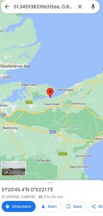
After many suggestions that I should do so, I'm contemplating adding GPS co-ordinates to my birding site guide to Cadiz Province. It's a daunting task as I'll probably have to copy & paste details of 500-600 locations. Unfortunately, I've never had a SatNav so, whilst I have some idea how to put in a destination when it's an address, I've only the foggiest notion of what's the best (or most widely used) method of feeding in the co-ordinates. Being somewhat old school in such matters, my first notion was to use longitude & latitude which has the advantage of using only two sets of six numbers (e.g. 51°20'45.41"N 0°53'21.10"E) but in terms of completing the task has the big disadvantage of being somewhat laborious for me to do via Google Earth (which seems the only way to do it unless someone knows a better). Google Maps digital degrees are easier for me to copy & paste but with two sets of 17 numbers (51.345938339631566, 0.8891813541144623) it must be more tiresome to type in & it's easier for users to make errors. What3Words has the same level of convenience for me as using digital degrees (///scratches.formal.graduated) and seems just as easy (or easier) to use as the first option. However, I'm not sure all SatNav systems support What3Words or whether people actually use the system (and do you always have to add ///)? Suggestions & help are welcome!