• Welcome to BirdForum, the internet's largest birding community with thousands of members from all over the world. The forums are dedicated to wild birds, birding, binoculars and equipment and all that goes with it.

    Please register for an account to take part in the discussions in the forum, post your pictures in the gallery and more.
ZEISS DTI thermal imaging cameras. For more discoveries at night, and during the day.

Norfolk birding (20 Viewers)

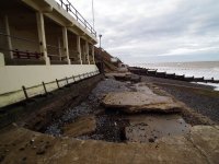
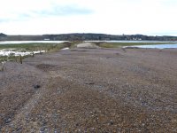
Where's that looking towards Canucklehead?

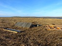
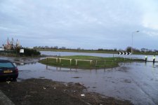
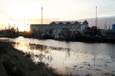
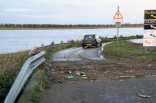
By the look of it, it was taken from the permissive path from Mucklebourgh to Kelling Hard looking west. The big 'island' is Gramborough and the smaller one Little Eye. The black sacks were a stack of silage bags now spread over Kelling/Salthouse marshes. Somewhere in the bottom right is a Cley boardwalk and bits of North Hide!!

John

www.kellingnature.zenfolio.com

cross posted with three others
 
Last edited:
More pics from Kelling this am

As John says, there is a lot of debris washed/blown down to the Kelling end.

We were guessing first pic shows bits of North Hide in the field behind Kelling Quags; second looks to me like one of the North Hide rafters on the beach just west of Kelling Hard (looking towards Sheringham); the chunk of boardwalk in the foreground, presumably from Cley, is floating in the debris where the Quag used to be.

There was an enormous amount of reed which had been washed down as well - visible in the pictures. There seems to be very little left standing between Kelling & Cley. There were at least 17 Bearded Tits at Kelling looking for any reeds, but ending up in the brambles and patches of dry grass.
 

Attachments

  • P1030681.JPG
    P1030681.JPG
    145.4 KB · Views: 640
  • P1030676.JPG
    P1030676.JPG
    139.2 KB · Views: 322
  • P1030652.JPG
    P1030652.JPG
    131.5 KB · Views: 307
There was an enormous amount of reed which had been washed down as well - visible in the pictures. There seems to be very little left standing between Kelling & Cley. There were at least 17 Bearded Tits at Kelling looking for any reeds, but ending up in the brambles and patches of dry grass.

Very worrying news if large amounts of reedbed have been flattened.
 
Boal Quay, King's Lynn, The Docks and the road to Lynn Point at 7.50am this morning after the tide.

More pictures on my blog.

Penny:girl:
 

Attachments

  • IMG_8395 crop.jpg
    IMG_8395 crop.jpg
    180.2 KB · Views: 226
  • IMG_8404 crop.jpg
    IMG_8404 crop.jpg
    207.9 KB · Views: 207
  • IMG_8408 crop.jpg
    IMG_8408 crop.jpg
    256.1 KB · Views: 221
Shocking pics from Cley. I visit N. Norfolk at least five times a year, I'm saddened to think of the devastation under the flood where the freshwater ecosystem is destroyed |:(|

I can't imagine what Blakeney Point looks looks like - is it still there?!!
 
Shocking pics from Cley. I visit N. Norfolk at least five times a year, I'm saddened to think of the devastation under the flood where the freshwater ecosystem is destroyed |:(|

I can't imagine what Blakeney Point looks looks like - is it still there?!!

Blakeney Point is natural unlike the shingle ridge, it will survive almost anything that is thrown at it, any breach is soon replaced. What has not survived is the majority of the 100`s of Atlantic Grey Seal pups recently born at the point, along with about 400 lost in the Horsey area.

John
 
All of the photos on here are shocking to view! i can't believe the devastation this storm has caused. Myself and my wife are from Derbyshire but visit Norfolk for around six weeks each year, birdwatching and wildlife watching in general, and i have, on a personal note, been visiting Norfolk for over 25 years and it has been heartbreaking to see the damage caused.

Our thoughts go out to all those affected by the shocking and tragic events witnessed over the past day or two. We have seen the photos but can't imagine seeing the destruction to all the reserves we so love in the flesh....very upsetting indeed.
 
Blakeney Point is natural unlike the shingle ridge, it will survive almost anything that is thrown at it, any breach is soon replaced. What has not survived is the majority of the 100`s of Atlantic Grey Seal pups recently born at the point, along with about 400 lost in the Horsey area.

John

The shingle ridge is a natural feature also. What was unnatural was the annual bulldozing of the ridge by the Environment Agency that took place until 2007.

Since 2007 the shingle ridge has been allowed to find its own natural profile and will gradually migrate inland, as Blakeney Point has been doing for years. This will inevitably mean more frequent overtopping of the bank onto the marshes but the improvements the Environment Agency made to the outfall sluices along beach road and the re-routing of the River Glaven was designed to allow more rapid evacuation of flood waters than was possible in 1996. A lot of the ecological damage in 1996 was caused by saltwater sitting on the marshes for weeks. If the saltwater can be evacuated quickly and the water management system purged with freshwater, hopefully the damage to the habitats will be lessened.

Over time, the marshes at Cley and Salthouse will become more saline but will still be fantastic places for wildlife. The freshwater reedbed interest is being re-created by NWT and EA in the Fens at Hilgay.

Rob

Sorry Rob. I meant it was unnatural in its present state ie height, due to bulldozing. It is gradually finding its own level and will be stronger than the loose shingle is,but this will mean salt water gets into the marsh more frequently. The lowering of the Northern end of the East bank should get the water out of Popes marsh and the Kelling/ Salthouse area as fast as the new sluice on the West bank can manage.

John
 
Last edited:
I have had a look at the Titchwell Reserve and this is what it has said about the condition of the boardwalk

Important notice

We are open again but there is limited access to the beach due to the collapse of the beach boardwalk.

Titchwell is our favourite place of all and I hope that that our up and coming week at Norfolk has not been ruined because of the storm!

Any suggestions of inland Reserves area to visit at all?

Regards
Kathy
x
 
Last edited:
Brancaster 0830-1025

Beach Road defences breached in 5 spots. Sure this will be closed by EA on H&S grounds. Gypsy Lane sea defence also breached same applies. Golf driving range produced Jack Snipe, Grey Plover. Stonechat along Beach Rd.

Staircase access to beach, non existent, climb over rocks. Very little left of the dunes towards Titchwell.
 
Blakeney Point is natural unlike the shingle ridge, it will survive almost anything that is thrown at it, any breach is soon replaced. What has not survived is the majority of the 100`s of Atlantic Grey Seal pups recently born at the point, along with about 400 lost in the Horsey area.

John

Updating this statement, this morning over 1200 seal pups were counted on the point. The previous news I think was based on the Horsey pups lost and the fact nobody could believe the point ones would have survived. Am told the counters were amazed at the survival of virtually all the colony.

John
 
Sheringham seawatching shelter survives!
Despite the promenade in front of the shelter being hammered, the shelter itself seems remarkably intact. Hopefully the council will have it all sorted by August!

Mick
 

Attachments

  • image.jpg
    image.jpg
    172.5 KB · Views: 370
Devastating photos & news on here, so very sad. We have visited your coastline a few years now & have grown to be very fond of it. Thoughts are with you all at this difficult time.
 
Peewit, you should be OK visiting Titchwell. I was there yesterday and the beach is accessible, just not via the boardwalk. The staff on site will be able to advise further.
 
Last edited:
Sorry Rob. I meant it was unnatural in its present state ie height, due to bulldozing. It is gradually finding its own level and will be stronger than the loose shingle is,but this will mean salt water gets into the marsh more frequently. The lowering of the Northern end of the East bank should get the water out of Popes marsh and the Kelling/ Salthouse area as fast as the new sluice on the West bank can manage.

John

Had a look at Cley today and was encouraged by the rate at which the floodwater seems to be dropping. The new sluices seem to be doing their job!

Not quite as fortunate at Burnham Deepdale where the sea defences have been breached. Not sure how the water will be evacuated from there. Gypsy Lane at Titchwell has also been breached and the fresh marshes at Brancaster are now inundated.

Snettisham has also been badly damaged with one hide destroyed and another lifted off its footings, turned 180 degrees and dropped back at a 45 degree angle.
 
Salthouse & Kelling saltmarshes?

Walked along the beach from Kelling to Salthouse Little Eye today. Would have gone further but for the new tidal (?) channel through the shingle ridge which blocked our way! We had wondered why the water seemed to have gone down much faster than 2007, so now we know - it was really racing out, gouging its way. No need to wait for the sluices. The bottom of the channel looks so low that it may be below high tide level in future, so the freshmarshes at Salthouse & Kelling may be saltmarshes in future! Is this what we call 'reprofiling' of the shingle?

Salthouse beach car park is completely lost under the shingle and amazing the way the shingle ridge either side has just been completely flattened.

Few new pics attached: the new channel; Salthouse beach car park looking west from Gramborough; the beach car park, if you can believe it; Salthouse beach road.
 

Attachments

  • P1030735.JPG
    P1030735.JPG
    129.4 KB · Views: 509
  • P1030700.JPG
    P1030700.JPG
    138.4 KB · Views: 493
  • P1030715.JPG
    P1030715.JPG
    175.2 KB · Views: 515
  • P1030721.JPG
    P1030721.JPG
    151.5 KB · Views: 524
I skirted the edge of Surlingham Church Marsh today - I didn't try, but suspect you'd need waders for the paths down to the river. The birding highlight was a (ringtail) Hen Harrier over at 12:30.
 

Users who are viewing this thread

Back
Top