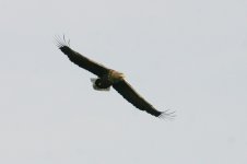
Good news! White-tailed Eagle Project already part of Ireland's tourist trail
White-tailed Eagle mention*
See here for full article and map etc:
http://www.belfasttelegraph.co.uk/features/daily-features/article2385166.ece
The Belfast Telegraph
Walk of the Week: Old Kenmare Road
Muckross House to Gowlane Cross
Friday, March 23, 2007
A mere one hour's flight from Belfast lies one of Ireland's most renowned wilderness areas. Killarney National Park is home to rushing rivers, twisted ancient oakwoods and mountain after mountain - culminating in Ireland's highest peak, Carrantuohill, in the heart of Macgillicuddy's Reeks.
Encompassing the Killarney Lakes and the Gap of Dunloe, it was one of the first national parks to be designated in Ireland and is one of only two Biosphere Reserves on the island.
While the area lures mountaineers and mountain bikers who like a challenge, this walk takes you along a marked route using the Old Kenmare Road, a disused green road. The 12-mile route will require a reasonable level of fitness, good hiking equipment and waterproofs.
Directions
With most walks in the National Park, it's as well to be accompanied by a guide or at least well prepared with maps and compasses - it's very easy to stray a long way off the beaten track.
Our walk, organised by Walk Killarney, began from the car park at Muckross House, with easy paths along the shore of Muckross Lake. Signs directed us towards the Kerry Way and Torc Waterfall.
We climbed steep steps up the side of a waterfall, continuing through woodlands until we reached Torc Old Bridge.
From here, we followed the Kerry Way signs to the left, which brought us onto open heath land at Crinnagh Glen and continued into Esknamucky Glen between the shoulder of Cromaglan Mountain and Stumpacommeen. Here, the road narrows into a bridle path over mountain and bog, reinforced with railway sleepers.
The walk then descended through the twisted, mossy oakwoods of Ullauns Wood, famed for their lichens and mosses and home to the elusive pine marten.
Turn left at the T-junction, following the Kerry Way signs along another stretch of rocky road.
The next stretch was a sustained ascent, muddy and rocky at times, until we reached a height of 331 metres at the Windy Gap between Peakeen Mountain and Knockanaguish.
We then descended past conifer woodland and reached Gowlane Cross, where the road opens to traffic. Continuing along the tarmac road brings you into Kenmare.
What to bring
As a general rule, it is best to be over-prepared than under-prepared. Waterproof and windproof clothing are essential and strong walking boots are also advised. Walkers should carry enough food and water for the walk and for emergencies as well as a first aid kit. You are also advised to inform someone of your intended route before you leave.
The backdrop
The Kerry Way was created more than 20 years ago: a 135-mile, low-level, waymarked walking route over old droving paths and coach roads, taking in woodlands, valleys and coastline.
The Old Kenmare Road is the first section of the Way and takes in the formal gardens of Muckross House as well as the mountains and sessile oakwoods of Killarney National Park.
The start lies on the geological fault line known as the Millstreet to Muckross fault.
The sprawling mansion of Muckross House was designed by the Scottish architect William Burn and completed in 1843, the fourth house occupied by successive generations of the Herbert family for over 200 years.
In the 18th century, Killarney become something of a tourist mecca, attracting famous names. Poets Tennyson and Wordsworth were drawn by the romance of the landscape and writers Sir Walter Scott and Jane Austen eulogised about their visits.
During the 1850s, the Herbert family undertook extensive garden works in preparation for Queen Victoria's visit in 1861. An avenue of trees was planted along the Queen's Road years before her royal visit.
The footpath that leads up the side of the 60-foot Torc waterfall - home of the rare Killarney fern - takes in magnificent views of the Killarney lakes.
In Crinnagh Glen, the furrows and stone walls of a pre-famine village provide a stark reminder of harsher times. Stones had been gathered up and left in piles, clearing the land for cultivating the potato crop - the shape of the ridges indicates the last crop never left the ground. Some 262 people were recorded living in the glen in 1841, but by 1861 not a soul remained.
The highest point of the route is at Windy Gap, between the mountains of Peakeen and Knockanaguish, 330 metres above sea level, followed by a descent that will command stunning views of Kenmare Bay and the highlands and islands beyond.
Crinnagh Glen is the haunt of the only purebred herd of Irish red deer in the country. The herd now numbers more than 650 - descended from red deer that brought to Ireland some 4,000 years ago.
Sharp-eyed walkers may spot peregrine falcon or merlin, and the area is known as the home of the bank vole, which was first identified in north Kerry in 1964 and has now expanded into the National Park.
*This summer sees the start of a major project to reintroduce the white-tailed eagle to the glens with the release of 15 chicks from Norway.
Walk Killarney is running a series of group walks marking public holidays - the next are the challenging Paps of Danu walk on Easter Saturday, the difficult Tower to Torc route on the Sunday and a half-day loop walk through Muckross Peninsula and Dinis Island on Easter Monday. Details are available at
www.killarney.ie.
Alternatively, there are walking weekends run by the Brehon Hotel in Killarney town - which provided a welcome haven at the end of a rainy day's hiking with its foaming baths and luxurious spa facilities. The hotel can fit in with Walk Killarney's schedule or arrange for guests to do their own walks with a personal guide. Two nights' B&B and one dinner are included in the 199 euro price.
Fact File
Walk Name: Old Kenmare Road
Area: Killarney National Park
Nearest Town: Killarney or Kenmare
Distance: 12 miles. Many shorter routes available in the area
Terrain: Old green roads which can be very muddy and rocky and bog laid with sleepers
Refreshments: Tea rooms at Muckross House. Lots of restaurants and bars in Kenmare
Publications: Kerry Walks by Kevin Corcoran; various walking guides available at tourist offices. Website at
www.killarney.ie
Ordnance Survey Map: Ordnance Survey Ireland Discovery Series 78, Sraith Eolais, Kerry
Walk Developed By: Part of the Kerry Way