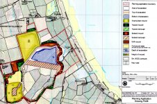
Regarding the map you saw. Did 'the area to be mined' really encroach 'right to the edge of Cresswell Pond', or was that an impression given by others, because no maps that I've seen do that. Was the map the early consultation document that I saw in the cafe at Cresswell some time ago and which was already well out of date by the time I saw it, having been superceded by other amendments that showed a reduced land take, but which I feel the opponents were not in a hurry to publicise. It even still showed overburden storage north of Druridge Lane - an idea long since abandoned after early consulations.
More importantly, was it the plan showing the
actual boundaries as contained in the recently-submitted planning application?
This is a link to the actual planning application documents. It's worth a look, especially the Environmental Impact Assessment and the Early Restoration Proposals - you might be pleasantly surprised.
http://www.banksgroup.co.uk/highthorn/project-details/planning-application/
The plans show that the
area to be mined comes nowhere near Cresswell Pond. The site boundary does indeed come down to the northern edge of the field holding the north pool, but this is simply the planning boundary, not the excavation area. The area to be mined is actually 1.3km to the west of this at its closest point - getting on for a mile away. The fields near Cresswell pond aren't even going to be used for soil or overburden storage, nor even stripped of soil. The site method of working plans and the geology plan show this.
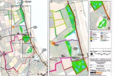
The Early Restoration Plan shows the sort of benefits they are aiming for in advance of the working of the site. There will of course be the standard post working restoration, where the site will be restored to farmland, with some new ponds and woodland planting as well as hedges, but this advance restoration is particularly interesting. The company has control of the surface of some of the land outside the proposed working area and they are going to be using this control to make improvements from the word go.
I've had a quick look at these early restoration proposals and we should feel encouraged. From north to south I spotted the following;
1. West of the old coal road, stretching up to the East Chevington boundary they are proposing a series of new pools the 'Chibburn Pools', totalling 11 hectares with new species rich planting to supplement them.
2. South of this, next to where Druridge Pools discharge to sea through the Dunbar Burn, they are proposing 4.5 Ha of new pools and habitat.
3. West of the existing Druridge Pools Reserve, a further 6 Ha of new pools between the existing reserve and Chibburn Preceptory.
4. South of Druridge Farm, opposite Druridge Plantation, more pools in the fields there, an area they are calling Druridge Ponds, 18.6 Ha of new pools and habitat.
5. At Bell's Pond they are proposing further enhancements with 9.2 Ha of species rich grassland replacing the current pasture around the ponds and the outlet stream.
That all sound like a pretty good deal to me- a load of new wildlife habitat outside the working area, most of it even outside the site boundary and before the site really gets going, not as you say in 10 or 20 years time. Some 'Destruction', eh?
http://www.banksgroup.co.uk/highthorn/benefits/wildlife-and-open-spaces/
Such 'advance restoration' is nothing new. We were doing it on sites in the mid-80s, usually in the form of tree planting, but also other works.
The impact on adjacent wildlife habitats during working would be no greater than it was on those same habitats while the workings of the other operations progressed in the past The wildlife couldn't have given a stuff. Indeed I used to have an impressive list of birds and wildlife that I saw on operating sites. My first pochard was on a flooded area of Togston site and some of my first snow buntings were on a subsoil storage mound at the north end of that same site at the end of the 70s.
On a working site there are vast areas where no machinery goes near for months at a time, or even longer and these hold a surprising amount of wildlife - I've had roe deer, foxes, badgers, hares, breeding shelduck, breeding little owls, breeding curlew (all on Druridge Bay sites) and (on a site we had at Penshaw) breeding little ringed plover on the overburden mound as well as little owl at the same place. The disturbance on an operating site to wildlife isn't as extreme as you might think and the actual active area is only a tiny proportion of the whole at any one time, with undisturbed areas in advance of the working void and replaced material awaiting progressive soil restoration behind it. The public doesn't get to know about these places, because the public isn't allowed there to disturb them.
In the last few years I was at Stobswood (about 2001 - 2003) we had a particular rarity. A peregrine nest. Nothing particularly rare about that you might say, but this nest was actually below sea level. That's rare. To the nesting pair the end wall, which on a site that size remained fairly static for long periods is nothing more than a cliff - and what's more a cliff without human disturbance other than the machines operating a few hundred metres away. This pair nested at a place about 60 metres or so down the face, at a point where the ground level was only 42 metres above sea level, just behind Stobswood East Farm. They fed on the numerous feral pigeons that also inhabited the area and kept the site personnel entertained when their young were fledged by carrying out food passes of pigeons over the cut. After the P&H dragline 'Ace of Spades' finished its task and was awaiting dismantling, they often used to perch on the dragline while it was parked up. When the site was eventually backfilled after working, they moved on.
Druridge Bay Country Park was attracting wildlife while the adjacent sites at Ladyburn and Radcliffe were working. Hauxley Nature Reserve, then just the ponds with vegetation establishing were bringing in a multitude of waterfowl and waders while Radcliffe Site, of which it was a small part was still producing coal.
When we were restoring East Chevington site in the mid 90s, I used to take my binoculars in my Land Rover when I was doing inspections, because even then, at migration time we would regularly have a marsh harrier hunting over the reeds on site near Chibburn Mouth on the way through, presumably to Scotland. Motor scrapers and other equipment including 85 tonne dumptrucks were in the meantime constructing East Chevington nature reserve, bring in the clay for the pool lining and shaping the surroundings.
I've got a photograph of the far bank of Linjton Lane Reserve covered with wigeon, while on the other side of the fence just behind them 50 tonne Terex dumptrucks get on with the business of working Linton Lane opencast. More recently that same reserve had got happily on with it while Butterwell coal disposal point (built 1976) worked out its life and more recently was demolished for the extraction of the coal beneath it (see photo below of the overburden mound being removed after working was finished - taken from the Linton hide in April 2015 - the bush at the bottom of the photo is on the reserve. The pond was covered with ducks, gulls, geese and dabchicks).
Give wildlife somewhere to rest and feed and it will take advantage of it. Weed seeds growing on stripped areas of soil or on ex-farmland awaiting the workings progress, small ponds trapped against soil stores, settling lagoons full of sticklebacks and eels; they all attract wildlife - more so that the short pasture with sparse stunted hedges and few trees that the area consisted of before working - much like the present area behind Bell's Farm that provides a resting space for geese in the winter (as does much of the rest of the bay) and not much more.


")