phyllosc
Well-known member
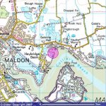
Attached is an OS map of the area - it doesn't quite match the aerial photo I posted earlier in the week.
This time I think I've got the boring technical stuff right so it should load up on screen.
I tend to walk the section of river bank between river and the flooded gravel pits, starting at Heybridge Basin. If the tide is high or there are few birds around I cross over to the canal and walk this way back to the Basin. To the north on the map there are some more gravel pits which I do very infrequently as I was once chased by a huge black dog and only avoided a mauling by vaulting a fence - no small job for a fat fortysomething, I can tell you!
Charles, for your patchwork studies: the river is tidal and thus brackish. The gravel pits are fresh water and have reed and bushy scrub around them. The scale is 1 kilometre to each grid square.
Dave