Day 10 - Tuesday
That was the end of staying in one place. From now to the end it would be travelling birding, stop overnight, move on. With everything packed up, I was free to bird by the hotel until the boys appeared with their cases and stuff. A couple of Cassin's Finches went by, the Violet-green Swallows were still feeding their young on the telephone lines and a Red-shafted Flicker scorched by without giving decent views. Several American Robins were also keeping their distance.
Soon we were all in our places in the car and setting off. Just outside Cooke City Maz thought she had a Moose up a side track, so we turned round as soon as we could and returned to check it out. On the way back past Steve confirmed he had also seen the animal, though he thought it was more likely a deer. We turned around again and drifted the car to a stop with a view up the track. The deer was a yellow concrete mixer and string of the trip to date - multiple observers even!
With that behind us, we followed our route of a couple of days previous up the Beartooth Highway onto the top of the mountains. I had intended our route to turn off along the Chief Joseph Scenic Byway ("What sort of name is that for an Indian chief?" grumbled Steve) but Mildred put her foot down and sent us the other way. I had a quick look at the map, discerned her intent to be to get on the Interstate as quickly as possible and decided not to argue. It was going to be a longish day and if Mildred thought this was the quickest route, fair enough.
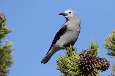
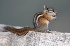
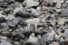
We had a quick look around on top but there was still no sign of Rosy Finches, Ptarmigan or either Bighorn Sheep or Wild Goats. We set off down the far side and almost immediately the road became steeper, with longer falls and tighter hairpins. Maz remained stoically unworried but I got a bit twitchy. We stopped at a turnout which had proper toilet blocks, not just a single long-drop composter, and found that it also had Yellow-pine Chipmunks intent on mugging tourists and Clark's Nutcrackers that showed point-blank in the blazing sunshine. Hurrah, boys! There were also Golden-mantled Squirrels but these seemed shy and I only got a brief view of two before they disappeared. Pity, as they were brighter than the ones we had photographed - oh, it must be six months back now, at the start of the trip! Photos taken, we set off downhill again.
The steep roads weren't too terrifying and I only whimpered a bit before their very steepness dropped us about four thousand feet to the valley floor in a very short time. Down at this level (by the way we were now well inside Montana) the land reverted to thick grasses and shorter, scrubbier pine trees: Ponderosas instead of Lodgepoles. Despite the bright sunshine Common Nighthawks were feeding overhead - they really do let down the name of the nightjar tribe. We saw occasional pairs of Sandhill Cranes in fields, the odd Turkey Vulture rocking gently on the thermals, and a couple of wire-perching American Kestrels in silhouette.
We hit the Interstate at Laurel and pretty soon we were passing through Billings, Montana, which is a big industrial sprawl best left behind, which soon it was. From there it was onward to Hardin where the road turned South across the low, rolling, undulating grassland hills towards Sheridan.
However, we didn't get straight to Sheridan, because a brown sign pointed off the highway with the legend (literally): Little Bighorn Battlefield National Monument.
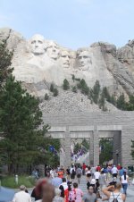
Right turn, Clyde. We came off the Interstate and followed signs up to the entrance to one of the best-known and probably most misunderstood, mythologised battlefields in the world. A full-blood Indian, with a long black plait and a crisply ironed light blue shirt, took our money and directed us to the car park, which was being resurfaced and causing a bit of congestion.
Now I have an interest in military history and I've walked a few battlefields in my time: the Normandy beaches, Sedgemoor, Tumbledown - I guess the Mohne Dam counts after a fashion - but I was expecting to visit them and this took me completely by surprise, and the neat rows of graves in the Military Cemetery with its specially planted trees and neat lawns brought a slight pricking to the corners of my eyes. I was also feeling that America had done it to me again. When I got to Sacramento, California, in 2000 I had this strange feeling of "This is Sacramento! I can't be here, its a place in history - and the movies...." I had that feeling again now. This is the Little Bighorn, I can't possibly be here.... We decided to start at the top of the hill.
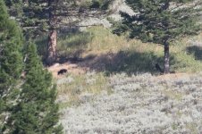
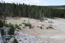
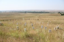
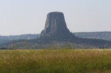
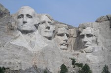
It was midday, there was only a light breeze, there was no shade away from the cemetery and the sun was blazing down. It was hot as hell and sunglasses-bright to boot. We followed the concrete path up the side of the battlefield tour road for a hundred yards, and there was a square wrought-iron fence enclosing a number of marble headstones scattered across the hilltop. This was Last Stand Hill, where Custer and the forty or so troopers who made it this far with him were finally overwhelmed by the largest contingent of fighting Indians that ever met the US Army on the plains.
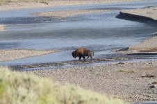
And you can see why. Hill? Its barely a mound. Yes it has an identifiable top, and looking around you can see its the only place within a mile at least where men could make any kind of a stand, especially when being driven across the ground by the enemy - but it was never going to work. Down beyond the headstones and the fence, a long open shallow slope runs a mile or more down to the idly meandering Little Bighorn River with its thin screen of riparian woodland and beyond, the flats where the scouts had reported the biggest number of Indian lodges they'd ever seen.
There is nothing, absolutely nothing, to stop the several thousand well-armed braves from thundering up that shallow slope in the mass, straight at troopers with only whatever remained by then of their 150 issued rounds for their single-shot rifles and 24 for their Colt revolvers. The final fight must have been over in no time at all.
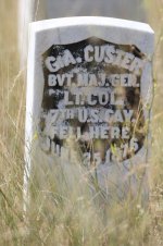
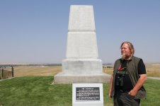
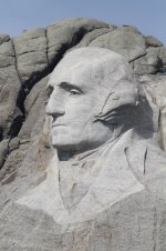
The headstones mark where the bodies were found, but the Army subsequently reburied them together under the 7th Cavalry memorial right at the top of the hill - crest of the ridge might be more accurate. Custer is not there. His remains were sent back East and buried at West Point.
We left the hilltop and investigated the visitor centre, which has a very fine collection of contemporary and relevant artefacts, from Custer's uniform to weapons found on the battlefield. One of the Springfield rifles displayed has been forensically linked to a fired cartridge case found elsewhere on the battlefield: simultaneously providing provenance of the find and emphasising the movement that was a feature of the battle.
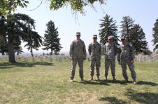
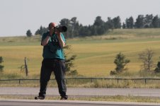
We walked around the Cemetery, which is slightly spoiled by a couple of noticeboards with some truly awful doggerel memorialising (see? I'm really getting American English!) the fallen. Major Reno was buried there after dying of old age. Four modern members of the US Army were also paying their respects and agreed to line up for a photo, for which I was grateful.
Back in the car, we set out on the battlefield drive. The odd thing is, the landscape is so ordinary: so uniform, if you like. For twenty miles in any direction you look, there is just this same array of low almost-hills with their gold-burnt wavy grass. Its all the same, but this bit has this strange significance attached to it.
At the far end of the drive is Major Reno's battlefield. Reno (7th Cavalry second-in-command) was detached by Custer with several companies of the 7th Cavalry to attack the Indian village just as Custer drove in from the other end. It wasn't an altogether bad plan, but it didn't take account of the numbers of Indians present and it wasn't properly co-ordinated. Reno went in early and was driven back, firstly across the river into the thin woodland and then back up what are often described as "rocky bluffs", where his detachment met up with that of Captain Benteen with the pack train and by rapidly digging trenches, using the wagons as cover, having the good fortune of ground in front of them that was just sufficiently broken into little ravines instead of open slopes, and maintaining perfect organised, fighting discipline, they held out until relieved after two days. The Indians couldn't get at them quite as easily as they could Custer, and that saved them. But the difference in the ground is far less than some books seem to suggest.
The massacre is part of the mythology, but the 7th Cavalry wasn't annihilated at the Little Bighorn. They lost the CO and 262 other men, but over half the regiment including the 2IC and the Quartermaster survived despite over 24 hours of fighting against enormous odds. And the Indians were well armed, even by comparison with the Cav: over 200 of them had repeating rifles/carbines which could provide a huge volume of fire for a short time before being reloaded, and many others had single-shot rifles. Despite that, when Custer said before the battle that the 7th Cavalry could handle anything it would meet, he wasn't so very far wrong. What doomed his command was poor reconnaissance, unsound tactics and most likely more than a touch of arrogance. What saved Reno's, ultimately, was their training, and that, most likely, was down to their CO.
The Little Bighorn had one last surprise - more of a shock really - as we left: Steve was driving us back to I90, on the bridge over the road in fact, when up our side of the road straight at us came a car. Steve said later that his first thought was that perhaps he was on the wrong side - but he wasn't, they were! Luckily the other Brit crew (surely they must have been, driving on the left straight at us) realised their mistake and lurched violently across to their own side of the road just as we all began to go AAARRRRGGGHHH! It was good to get back on the empty dual carriageway Interstate and start getting the miles down again.
John
Pictures:
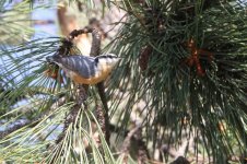
Clark's Nutcracker
Yellow-pine Chipmunk
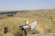
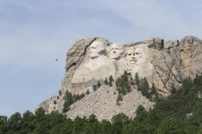
Last Stand Hill on the Little Bighorn. Look at the shallow slope and absence of cover. No chance at all.
Lieutenant-Colonel (brevet Major-General) George Armstrong Custer's headstone marking where he fell.
7th Cavalry Memorial


 2014_08_10 (3h)_Ridge_Road (800x533).jpg335.9 KB · Views: 47
 2014_08_10 (4)_Pika (800x533).jpg355.2 KB · Views: 37
 2014_08_10 (4a)_Pika (800x533).jpg291.3 KB · Views: 40
 2014_08_10 (4c)_Beartooth_Highway_Hairpins (800x533).jpg297.7 KB · Views: 51
 2014_08_10 (4d)_Harlequin (800x533).jpg222.2 KB · Views: 68