• Welcome to BirdForum, the internet's largest birding community with thousands of members from all over the world. The forums are dedicated to wild birds, birding, binoculars and equipment and all that goes with it.

    Please register for an account to take part in the discussions in the forum, post your pictures in the gallery and more.
ZEISS DTI thermal imaging cameras. For more discoveries at night, and during the day.

eBird and Birding on the move (4 Viewers)

The solution here is to either submit two checklists, one for each hotspot (this is what I do), or one checklist to a third location (either personal or a hotspot) that includes both hotspots. Especially locally, I tend to make as many checklists as there are hotspots to report them to. A thorough morning or afternoon at my local state park could include five or more checklists, all to different small hotspots. I could make one big list for the day and report it to the main park hotspot, but that's less precise, much less helpful to others, and it's also just fun to build lists for each hotspot.

Optimally, of course, hotspots would be area-based. The only problem is that would require knowledgeable local reviewers who actually care to accurately define the borders.

Agreed in principle.

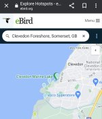
However, the creation of Hotspots is independent from local reviewers & indeed, independent from dedicated local eBirders. In addition, the manner in which the App works can provide false legitimacy to what on occasions is an insane proliferation of individual Hotspots within a small area. Because of the App, some Checklists will be randomly assigned to different Hotspots only small distances apart. Unfamiliar visitors just select a Hotspot unaware that it is little used and in reality, it should not have been created.

In those circumstances, the last thing I will do is submit four different Checklists to what would otherwise be a single Checklist representing a defined one hour walk from home. 😀

All the best

Paul
 

Attachments

  • Screenshot_20240112_043909_Chrome~2.jpg
    Screenshot_20240112_043909_Chrome~2.jpg
    130.2 KB · Views: 16
No because we know or can account for differences in the distances at which it's possible to perceive species. Either grossly (e.g. blanket approach for sea watches or prairies) or specifically based on knowledge of the place and/or the species. The corrections will be imperfect but better than trying to work with a "hotspot".
Yes, precisely. And the same is true of the current eBird approach, which can also account for the generality of hotspots, etc. and is much better than the approach of just recording birds by political subdivisions, e.g. county or state. It's all a matter of where you want to strike the compromise between accuracy and ease of use. Perhaps eBird will one day add an option to record encounter locations and for the user to affirm that such information is being diligently recorded. I think both these approaches will be accomodated then.
 
the creation of Hotspots is independent from local reviewers & indeed, independent from dedicated local eBirders.
I was under the impression that hotspot reviewers were the ones who created/approved new hotspots. Of course in some areas, those reviewers may not be local.
Because of the App, some Checklists will be randomly assigned to different Hotspots only small distances apart. Unfamiliar visitors just select a Hotspot unaware that it is little used and in reality, it should not have been created.
Indeed, this is a real problem. It would be solved by diligent eBirders, who pay attention and don't just automatically click on the recommended hotspot, or by diligent reviewers, who would correct obvious mistakes, or, once again, by area-based hotspots. With this, eBird wouldn't recommend hotspots unless all or most of the GPS track was inside the boundaries. The current model, with a hotspot as a single point is fatally flawed for >90% of hotspots.
 
I was sometimes considering starting using eBird. But the way how it works just annoys me so much. I do not wish to record "checklists" for "hotspots", I wish to record birds. I would like to be able to just record any bird, at the moment I see it and I would like this to be the location stored and provided to others. eBird goes wildly out of its way to make this difficult. Maybe it's not "stupid", but it's the chief reason why it's very unlikely to be ever getting any data from me.
 
I was under the impression that hotspot reviewers were the ones who created/approved new hotspots. Of course in some areas, those reviewers may not be local.

Indeed, this is a real problem. It would be solved by diligent eBirders, who pay attention and don't just automatically click on the recommended hotspot, or by diligent reviewers, who would correct obvious mistakes, or, once again, by area-based hotspots. With this, eBird wouldn't recommend hotspots unless all or most of the GPS track was inside the boundaries. The current model, with a hotspot as a single point is fatally flawed for >90% of hotspots.

I was using reviewer in the sense of reviewers of records. I see that Hotspot creators are also called reviewers. The reality of course is that the example that I gave of three Hotspots along a 400 metre stretch of path is simply daft. The proliferation of Hotspots looks like a response to challenges over their use as in this thread and elsewhere. Personal locations are fine! Precise locations are fine. I use them. Proliferation of Hotspots confuses me.

Of course, the Hotspot approach is a fundamental approach of the system so regardless of its advantages and disadvantages, compromising that approach in this way can only make the position worse rather than better. It confuses records. I took an existing Hotspot and built up a pattern of records and photos for a useful Illustrated Checklist for the location. Someone then created an overlapping Hotspot!

For the Hotspot approach to be sensible, Hotspots as you say need a minimum size and at least a basic area that a user can identify for themselves in the absence of definition.

I am not sure how a reviewer (meaning reviewer of records) would find the obvious mistakes to correct. Reviewers get records thrown up by recommendations for review and the filters. They do not trawl for geographically misplaced records and I am not sure how you would do so even if you wanted to do so. Also reviewers tend to do this mostly without thanks and sometimes the opposite.

I was sometimes considering starting using eBird. But the way how it works just annoys me so much. I do not wish to record "checklists" for "hotspots", I wish to record birds. I would like to be able to just record any bird, at the moment I see it and I would like this to be the location stored and provided to others. eBird goes wildly out of its way to make this difficult. Maybe it's not "stupid", but it's the chief reason why it's very unlikely to be ever getting any data from me.

Clearly not the system for you. I always kept lists of birds for locations & this was the standard approach to birdwatching amongst my peers so the system regardless of its flaws matches my approach since I was first interested.

All the best

Paul
 
Last edited:
When I hear people complaining, I am struck by the fact that it seems as if users think eBird is a personal listing utility/app. It is NOT. It is citizen science and tho imperfect, I am more than happy to defer to the scientists who have designed it and use the data. That it serves as a nice (for me) way to keep life lists etc. is a wonderful bonus. That it's not as full featured, friendly, precise, adaptable to personal preferences, as I might like, is unfortunate, but given that it's not an apple/microsoft big-bucks production - and volunteer dependent - I'm just grateful we have it at all!
 
I am not sure how a reviewer (meaning reviewer of records) would find the obvious mistakes to correct. Reviewers get records thrown up by recommendations for review and the filters. They do not trawl for geographically misplaced records and I am not sure how you would do so even if you wanted to do so. Also reviewers tend to do this mostly without thanks and sometimes the opposite.
With a good knowledge of the local hotspots and the birds that use them it's not too hard to figure out. I'm not a reviewer, but I look at all the checklists for my home county, and often find clearly misassigned checklists. The problem is most reviewers have too many counties to review, and most either wouldn't take the time to check or don't have the knowledge to pick out mistakes. But it's technically in their job description to correct misplaced checklists. Reviewers should have access to the GPS tracks without question, and the whole job would be much easier.
 
Perhaps eBird will one day add an option to record encounter locations and for the user to affirm that such information is being diligently recorded. I think both these approaches will be accomodated then.
It already exists. It's when you record a bird as an "incidental". I get the feeling that they're trying to move people in this direction anyway because (I believe) they're trying to get people to produce lists of shorter duration.

Aggregating to hotspot adds greatly to the error because you've no access to the geometry even if you know the duration or distance of the survey. This means you can't adequately account for habitat changes etc.

It's very unhelpful for other users as they generally want to know exactly where a particular rarity was in what can be a big area. Basically, the model is just wrong. Thankfully there are other apps out there...
 
With a good knowledge of the local hotspots and the birds that use them it's not too hard to figure out.
Very unclear how one can get this for any hotspot one didn't designate oneself as there are no boundaries.
I'm not a reviewer, but I look at all the checklists for my home county, and often find clearly misassigned checklists. The problem is most reviewers have too many counties to review, and most either wouldn't take the time to check or don't have the knowledge to pick out mistakes. But it's technically in their job description to correct misplaced checklists. Reviewers should have access to the GPS tracks without question, and the whole job would be much easier.
Not sure about that. The GPS tracks are (extremely) personal information and there are few checks on these volunteers. Basically this would present a massive opportunity for abuse. (There's also the "slight" issue that I can't easily download my own GPS traces---at least not using ebird.)

What would help is:

A) you have ability to contact checklist author directly (anonymously as in BF)

B) you have opportunity to report duff observations directly just as you can with images. At least this would help highlight the more egregious ones
 
When I hear people complaining, I am struck by the fact that it seems as if users think eBird is a personal listing utility/app. It is NOT. It is citizen science and tho imperfect, I am more than happy to defer to the scientists who have designed it and use the data. That it serves as a nice (for me) way to keep life lists etc. is a wonderful bonus. That it's not as full featured, friendly, precise, adaptable to personal preferences, as I might like, is unfortunate, but given that it's not an apple/microsoft big-bucks production - and volunteer dependent - I'm just grateful we have it at all!
It not open, it's not transparent and, when it comes to its data model, it's not well designed because the model is wrong. Just because it's citizen science that's no excuse, and precisely because it's that it should be open. Other systems get closer to this ideal...

(At minimum I'd like to be able to download all my own GPS traces...)

No one is making you use it, no?
 
Very unclear how one can get this for any hotspot one didn't designate oneself as there are no boundaries.
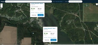
Many hotspots, while without specifically defined boundaries, are clear about the area they represent. For example, at my local state park there are several hotspots close together, for example: Hueston Woods SP--Marina and Hueston Woods SP--Beach. It's fairly easy to understand what areas these describe (see attached screenshot), and it's easy to recognize that a three mile traveling checklist didn't just cover the beach. And checklists like this make it unequivocally clear that they are wrongly placed. Of course not all hotspots are this clear, and it's certainly not possible to detect all (or even a majority) of incorrectly placed checklists. Obviously area-defined hotspots would eliminate this problem and make infinitely more sense.Capture1.JPG
Not sure about that. The GPS tracks are (extremely) personal information and there are few checks on these volunteers. Basically this would present a massive opportunity for abuse. (There's also the "slight" issue that I can't easily download my own GPS traces---at least not using ebird.)
Not sure I understand why tracks are so personal. Anyone can already see which hotspot you were at (so a close approximation of where you were), how far you traveled, and how long you were there. What difference does it make if they knew precisely where you walked? If eBird followed the data model you suggest, and recorded every location where you add a bird, then they effectively have your track, and it's public.
 
I was sometimes considering starting using eBird. But the way how it works just annoys me so much. I do not wish to record "checklists" for "hotspots", I wish to record birds. I would like to be able to just record any bird, at the moment I see it and I would like this to be the location stored and provided to others. eBird goes wildly out of its way to make this difficult. Maybe it's not "stupid", but it's the chief reason why it's very unlikely to be ever getting any data from me.
You are exaggerating. eBird makes it very easy to record sightings without using hotspots. You can create your own locations or simply submit your sightings from a track. But if you don't use a hotspot and bird in the hotspot, then your sightings won't be in the bar chart for the hotspot, so other birders will have difficulty accessing that information. That is the great thing about hotspots--you can quickly obtain a great list showing the birds seen at the hotspot, as well as their frequency and seasonality. In the past, such checklists were paper things available at a reserve; but with eBird, you can now access them online and they are updated in real time.

No app allows you to record "birds". At the most, some will allow you to record where you were when you heard or saw a bird--which may actually be an entirely different habitat from where the bird is. eBird doesn't currently have a means by which birders can specify that they are recording exact times and places of the encounter when they tick a bird, so it has no data of that nature. Perhaps in the future it will, but, personally, I would rarely if ever make such information public, and I'm not sure I would want a global database like eBird to make that information public either. There is too much potential for abuse.
 
I find the distinction between "observer location" and "bird locations" a false argument, when compared with the eBird option of "a hotspot a mile away". I also don't understand what is so unfathomable on the concept "I will record positions of birds as seen, without any other hassle, and this will be stored in a DB and made available if I wish (and I would) - and if someone wants to see data bundled in hotspot the DB will bundle them using this more detailed information, because it's a computer and it's very easy for it to do it".
 
I find the distinction between "observer location" and "bird locations" a false argument, when compared with the eBird option of "a hotspot a mile away". I also don't understand what is so unfathomable on the concept "I will record positions of birds as seen, without any other hassle, and this will be stored in a DB and made available if I wish (and I would) - and if someone wants to see data bundled in hotspot the DB will bundle them using this more detailed information, because it's a computer and it's very easy for it to do it".
--A distinction is not an argument, so your first statement makes no sense.

--To automatically bundle data not recorded as being in the hotspot as being seen in the hotspot would require eBird to determine the exact dimensions of every hotspot in the world on their maps. For some hotspots that might be easy, but for others very difficult, and to do it on a global basis would require enormous amounts of time and access to local knowledge.

--just because a birder is willing to share data through eBird does not mean it is good for the bird to share it. eBird already prevents sharing of information about sensitive species, and even sharing exact locations about non-threatened species would not be a good idea in many instances. While you might be able to make good decisions about such matters, I don't think all birders would be trustworthy or knowledgeable. So I personally don't think it should be an option.
 
just because a birder is willing to share data through eBird does not mean it is good for the bird to share it. eBird already prevents sharing of information about sensitive species, and even sharing exact locations about non-threatened species would not be a good idea in many instances. While you might be able to make good decisions about such matters, I don't think all birders would be trustworthy or knowledgeable. So I personally don't think it should be an option.

I have removed GPS co-ordinates in the narrative of a Checklist on request by an eBird reviewer (Gran Canaria Chaffinch). I have removed a photo of a Saker Falcon because you may have been able to tell the nest site from the wider geography (Georgia). I have changed a specific location Checklist to a Hotspot Checklist on request (Bearded Vulture, Morocco).

But on the point that additional functionality to allow individual selections to share exact locations more easily would be useful, then I cannot see the objection. You can do this any way. Giving an option to do it more easily seems unobjectionable to me.

All the best

Paul
 
(from: Aplicaciones externas útiles - eBird España)
Yes but this isn't from ebird itself and (iirc) you cannot bulk download your data with it. In fact, I already have ways of getting all my GPS traces, but not any official ebird way. My point is that ebird itself should be offering this. In Europe they would probably fall foul of data protection laws: these give you a right to see information held about yourself.
 
No app allows you to record "birds". At the most, some will allow you to record where you were when you heard or saw a bird
Well if we want to be really pedantic about it I'm sure there are rfid and other tag reader applications which would allow you to determine exactly where a bird is, after you first tag it. Certainly you can follow other people's tagged animals (see e.g. Animal Tracker - Apps on Google Play ). But of course none of this is the point. And I've been clear to (mostly) refer to "point of encounter"—meaning, of course, the location where the human becomes aware of the bird. Really, please have some more respect for the audience—it's blindingly obvious that the place you see or hear the bird from isn't (exactly) the place where the bird is, and no-one has claimed it is !
 
I was sometimes considering starting using eBird. But the way how it works just annoys me so much. I do not wish to record "checklists" for "hotspots", I wish to record birds. I would like to be able to just record any bird, at the moment I see it and I would like this to be the location stored and provided to others. eBird goes wildly out of its way to make this difficult. Maybe it's not "stupid", but it's the chief reason why it's very unlikely to be ever getting any data from me.
Have you tried using observation.org ?
 

Users who are viewing this thread

Back
Top