• Welcome to BirdForum, the internet's largest birding community with thousands of members from all over the world. The forums are dedicated to wild birds, birding, binoculars and equipment and all that goes with it.

    Please register for an account to take part in the discussions in the forum, post your pictures in the gallery and more.
ZEISS DTI thermal imaging cameras. For more discoveries at night, and during the day.

My Outback - Map (1 Viewer)

birdman

Орнитол&
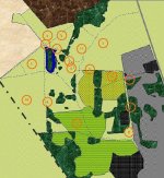
Well I threatened this, so for the hardened vicarious birders amongst you, here's a sketch map of my patch, with the sighting locations of some of the species I've seen up to now indicated.

If you have a slow connection, this may take a while to load, but I have only BT narrow band and it doesn't take too long for me.

However, here is your chance to back out!

I've only tested it on my own home PC, and it is just about legible if not fantastic. Don't know what would happen if you tried to detach it and scale it up.

First a Key to the colours:

Dark Green - Trees and Shrubs
Light Green (background) - Generally scrubby grass
Green with Yellow Circle - Root crop
Hatched Green - Cereal crop
Black or Grey - Private land (woodland within is also private)
Brown - Farmland (No Public Access)
Ivory - Housing Development
Blue - Water

The grey line to the top right is a major A road, the dotted grey line to the bottom left is a major rail line.

Distance from the pond towards the top left to the road is, near as damn it, 1 kilometre (5/8 of a mile) - so not a huge area you'll notice.

The land undulates but tends to rise from left to right, but not more than a very few metres.

I have inadvertantly missed off a few small areas of shrubbery, particularly alongside pathways, but it's mostly all there!

Sightings Locations as follows:

1. Skylarks and Hirundines
2. Whitethroat
3. Yellowhammer
4. Kestrel
5. Blackcap
6. Lapwing
7. Goldcrest & Treecreeper
8. Turtle Dove
9. Tree Pipit
10. Long-eared Owl
11. Kingfisher (in flight)

Any comments would be appreciated.
 

Attachments

  • patchmapsmall.jpg
    patchmapsmall.jpg
    218.6 KB · Views: 271
Hi Charles,

In an attempt not to do anything that would be incompatible with other peoples machines, I have used the standard Windows Textures and Patterns in Word. (Yes Word!... it was a nightmare!!!)

Some of the colours are "semi-transparent" and it may be that some of the hatching that you can see is down to resizing. I had to shrink it a bit to get down to BF dimensions.

Cheers.
 
A very good effort in my opinion.
I'm thinking of doing a similar thihg for my 'local patch'and it will be made considerably easier if the London A to Z maps are available online and down-loadable.
Don't hold your breath! and in any event the list is only 51 species.
 
Grousemore,

Why not use an arial photograph?

The technique I use is as follows:
  1. First locate your area using getamap. I've used CV3 3GW which is the postcode for warks wildlife trust HQ at brandon marsh.
  2. Once located I click on the historic map link.
  3. Make any minor adjustments to zoom level or position.
  4. Finally click the arial photo button.
    [/list=1]

    You should be able to do this for most areas, particularly London.
 

Attachments

  • brandon.jpg
    brandon.jpg
    72.6 KB · Views: 222
Birdman

A nice peice of work. I have lots of respect for those who watch and keep watching 'a patch'. I have often fancied watching one myself but either haven't found the right one yet,or I'm suffering from a kind of wonderlust that keeps me going about and about to different sites.

Dave Carr
 
Thanks for the feedback everyone.

I deliberately avoided attaching any of the downloadable maps as I am unsure about the copyright implications, although clearly, as I am not a cartographer, I used the map information for my patch as the basis for my map.

Also, I am still working on a more suitable method of putting the map together, as it is unmodifiable at the moment, except with great difficulty. For example, if I had attached it after yesterday evening's walk, I would have included the location of the Little Owls. But I cannot simply add that, but must reconstruct the whole thing from the objects I have saved in Word.

Grousemore, don't feel too ashamed of your 51. If you have read my report from last night, you will see that the Little Owl became species number 44 for me.

phyllosc, thanks for you kind comments. It is a very new thing for me to have this local patch, and I am helped by the fact that I am fortunate enough that my garden backs onto this area. Although I don't have a back gate, and therefore cannot get immediately onto the patch, it is less than two minutes' walk around the estate to pick up the footpath. If it wasn't so handy, I couldn't honestly say I'd definitely visit quite so frequently. As it happens, I can go "on a whim" or when there's a break in the weather - something that is increasingly more difficult to do the further away your favorite area is from home!

To everyone, I hope I've started a small trend, as I would be equally interested to see the local patches of you and other members.

:t:
 
Last edited:
A local patch forum would be a great idea. Really.

Don`t know if I could do one of those images though-I`m really cack-handed on computers (and the operating system on this computer is in Japanese to make it even more impossible).

Birdman and Walwyn-I`m impressed!!!!!
 
Yeah, I'd go along with the idea of a Patch Forum.

I think it would be sufficiently different from "Your Birding Day" which feels more like a "special" trip out, and the County/State etc. indices which I think are more for information only.

Anyone else got an opinion?

(BTW Stu, thanks for your kind comment)
 
I like the 'Patch Forum' idea very much guys. Any thoughts on what size and distance from home would constitute a local patch?
I'm thinking a maximum of 5miles as the crow flies (or Chough in Manx terms!) from doorstep to first entry point of the area considered. I think size of a local patch might be very difficult to determine.
 
Had a quick look Birdman and there seems to be a variety of ideas - the one I'm most enamoured with is the one that allows me to drive to my local patch!
The area I would consider my 'LP' is about 3 miles from the house and i guess the circuit on foot is about the same. I'll look out for the Patch Forum appearing and post something if and when it does.
 
birdman said:
I deliberately avoided attaching any of the downloadable maps as I am unsure about the copyright implications, although clearly, as I am not a cartographer, I used the map information for my patch as the basis for my map.
The OS maps: you can use up to 10 maps so long as they also contain the OS copyright. The aerial ones might be a bit more restrictive, they certainly want you to pay £24.95 for the high resolution versions. The low res ones seem to be a taster.

I use lotus freelance graphics to add location markers to the underlaying jpg. I suppose any vector graphics package would do though.

Stuprice68 - Don't be that impressed with my graphic it was obtained entirely by following links on the web. Birdman's one has had far more work put in being handcrafted.
 
I think that it may be dodgy publishing an OS map on a public web site!
I wrote to OS for permission to use a map based on theirs for a paper I am planning to do for our county bird report. They said that I could do so, free of charge, as it was for scientific purposes. (And provided I put the Crown copyright note in.)
 
Warning! This thread is more than 21 years ago old.
It's likely that no further discussion is required, in which case we recommend starting a new thread. If however you feel your response is required you can still do so.

Users who are viewing this thread

Back
Top