As promised here is the info regarding Sedgley Manor, sorry it is a bit drawn out, but it sets the scene and why I have chosen the boundaries for the area I have defined. The boundary is based on the 1844 tithe map which includes the nine villages that made up the 'ancient' Manor of Sedgley. It also makes for any interesting and different title/theme and includes a good variety of sites and habitats locally (See Sedgley Locally History Society (SLHS) website from which this info and map boundary is taken from).
Sedgley Manor comprises of the following nine villages - Sedgley (obviously!), Gospel End, Coseley, Upper Gornal, Lower Gornal, Woodsetton, Ettingshall, Cotwall End and Brierley (now Bradley). Total area is 7590 acres, with a boundary of @17.5 miles. It stretches from Himley in the west to Gospel Oak in the east (@5.5 miles, and Ettingshall in the north to Gornal Wood in the south (@3.5 miles). For the main, most lies within the Dudley Borough, but Gospel end encompasses Baggeridge, Himley and Penn Common to the west, Park Hill & Ettingshall to the north and Wednesbury Oak to the east which are located outside of the Dudley boundary but are within the 'ancient' Manor of Sedgley.
These days the recording area can be roughly split into two - Urban to the east of Sedgley and 'countryside' to the north, west and south of Sedgley.
There are a number of open spaces which are of local importance as identified in the 'Action Plan for Nature Conservation in Dudley (1995). and the 'Black Country Nature Conservation Strategy (1994). The latter includes all sites at the time within the West Midlands covering Dudley, Walsall, Sandwell and Wolverhampton>
These are the main sites identified within the Sedgley Manor which are SINCS, WCA's, SSSI's and LNR's. Wrens Nest is the only NNR within the recording area.
The following sites of interest in the recording area are:
Alder Coppice
Sedgley Beacon - (highest point in the West Midlands County @ 777ft), and the largest area of Limestone Grassland (CG3 category) within the West Midlands
Sedgley Hall Farm Park
Hurst Hill and Turls Hill (Swanbrook Valley)
Coseley Canal Cutting
Cotwall End/Moden Hill/Turners Hill (not Turners Hill in Rowley Regis!)
High Arcal & Tenacre Fields
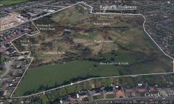
Wrens Nest & Parkes hall Res
Ruiton Quarry/Holloway (Has a fantastic population of Southern Marsh Orchids)
Baggeridge/Himley/Penn Common - Surprising how few records come from this area considering the range of habitats. I remember Wood Warblers breeding at Baggeridge?
Open water is a scarce habitat within the proposed recording area, which is why I have opted for the 'abcient' boundary as it encompasses the open water and wetland areas found at Baggeridge and Himley.
Birding and natural history recording will be mainly undertaken by pushbike and on foot - The best way to see more things, get fit, plenty of fresh air and minimize your carbon footprint! If you have an interest in plants, areas of wasteland, cracks in the pavement and gaps in wall provide plenty if interest!
Although most of the countryside in the recording area is to the north, south and west of Sedgley, the urban environment can be jus as rewarding.
Right! That has got the into to the thread done and has set the scene and boundaries1 I look forward to posting my own sightings and welcome those of others as well as your thoughts on this tread.
Please feel free to contribute and I look forward to reading future postings and maybe meeting other like minded people as I travel around Sedgley Manor.
Happy Birding
Gavin - Sedgley Birder


") at some stage:t:
at some stage:t: