


-
Welcome to BirdForum, the internet's largest birding community with thousands of members from all over the world. The forums are dedicated to wild birds, birding, binoculars and equipment and all that goes with it.
Please register for an account to take part in the discussions in the forum, post your pictures in the gallery and more.

You are using an out of date browser. It may not display this or other websites correctly.
You should upgrade or use an alternative browser.
You should upgrade or use an alternative browser.
RSPB Middleton Lakes (1 Viewer)
- Thread starter JHDraytonbassettpits
- Start date
More options
Who Replied?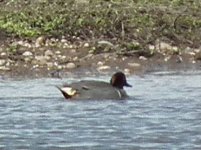
Phil Andrews
It's only Rock and Roller but I like it

Godwit were more likely to be Black-tailed?
Dick-E-Dipper
Well-known member
Godwit were more likely to be Black-tailed?
That was Quick Phil Reply before I had time to edito
")
56 species in around 3 hours this morning.
Goosander (1F) on North Pit
Pochard (1M 1F) on Dosthill
Black-tailed Godwit (x3) on Jubilee
Cett's Warbler in several different locations
Chiffcharr singing all over the place
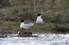
Lots of BHG mating, and they were noticeably trying to intimidate other species. The Cormorants were having none of it.
Apart from the Godwits, a few Lapwing and Oystercatchers, there appears to have been a noticeable cleaout of waders since last Sunday. No Avocet, Redshank, Dunlin, RP or LPR, at least whilst I was there. Hopefully they were just off feeding elsewhere.
I spoke to a couple in the North Pit hide who'd seen six Sand Martins over Jubilee around 8am, but I didn't see any.
Goosander (1F) on North Pit
Pochard (1M 1F) on Dosthill
Black-tailed Godwit (x3) on Jubilee
Cett's Warbler in several different locations
Chiffcharr singing all over the place
Lots of BHG mating, and they were noticeably trying to intimidate other species. The Cormorants were having none of it.
Apart from the Godwits, a few Lapwing and Oystercatchers, there appears to have been a noticeable cleaout of waders since last Sunday. No Avocet, Redshank, Dunlin, RP or LPR, at least whilst I was there. Hopefully they were just off feeding elsewhere.
I spoke to a couple in the North Pit hide who'd seen six Sand Martins over Jubilee around 8am, but I didn't see any.
Piccalilli
Steve Pick
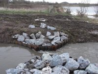
A picture of the new flume (channel restriction) in action and a couple of the potential consequences due to its location. Under today’s flood conditions the flume was generating about a 6-8 inches restriction ie water on the upstream side was generally 6-8 inches higher than it would be if the flume hadn’t been installed. This would be great if it held back water in the river but under today’s event the elevated upstream water level meant it filled the pool to the right of the Lookout. This in turn flooded straight into North Pit and thus in theory bypassing the flume. The levels on Jubilee Wetlands are the highest I’ve ever seen them so under last night’s conditions the flume has not been a success. Also the path to the hide and the pipe bridge was flooded by 6-8 inches making them only accessible with wellies and, possibly, without the flume then these may have remained dry. When I first heard about the flume I had assumed it would go as close to the river as possible and its throat width (narrowing) would be a lot narrower than has been installed – but what do I know. If this happens later in the season then yet again most nests will be lost.
ps - this is NOT a criticism of the RSPB as it's the EA who have dictated the flume dimension and location.
ps - this is NOT a criticism of the RSPB as it's the EA who have dictated the flume dimension and location.
Attachments
Last edited:
geoffw1946
Well-known member

Thanks for the update Steve. Why am I not surprised that the flume hasn't helped, I hope they have a plan B. I bet the river didn't even overflow it's bank or if it did then not by much. A high river shouldn't have caused any problem providing the outlet on North Pit is checked regularly.A picture of the new flume (channel restriction) in action and a couple of the potential consequences due to its location. Under today’s flood conditions the flume was generating about a 6-8 inches restriction ie water on the upstream side was generally 6-8 inches higher than it would be if the flume hadn’t been installed. This would be great if it held back water in the river but under today’s event the elevated upstream water level meant it filled the pool to the right of the Lookout. This in turn flooded straight into North Pit and thus in theory bypassing the flume. The levels on Jubilee Wetlands are the highest I’ve ever seen them so under last night’s conditions the flume has not been a success. Also the path to the hide and the pipe bridge was flooded by 6-8 inches making them only accessible with wellies and, possibly, without the flume then these may have remained dry. When I first heard about the flume I had assumed it would go as close to the river as possible and its throat width (narrowing) would be a lot narrower than has been installed – but what do I know. If this happens later in the season then yet again most nests will be lost.
ps - this is NOT a criticism of the RSPB as it's the EA who have dictated the flume dimension and location.
SteveAtkinson
Well-known member
Thanks for the update Steve - disappointing.
Piccalilli
Steve Pick
............ I bet the river didn't even overflow it's bank or if it did then not by much. A high river shouldn't have caused any problem providing the outlet on North Pit is checked regularly.
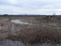
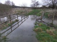
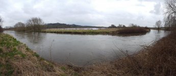
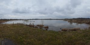
Geoff - You are correct. The river was/is some way off breaking its bank as the first picture. Levels are even higher on the reserve today although you can just about cross the pipe bridge. Hide path still under a few inches of water though. The second picture (North Pit from the 2 benches) just shows how high it is. The vegetation just sticking out the water on the left hand side is the strip of land that usually divides the west channel. The only island now visible is the long one and again I think that is only vegetation.
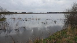
On Jubilee (3rd picture taken looking south from lookout path) then its just one pool with no islands or spits visible. Even the west scrape division bank has been breached and that is totally full again.
Perhaps the outlet from North Pit is blocked as this is usually the least affected pool as it generally runs out as fast as it runs in.
Steve
Attachments
geoffw1946
Well-known member
I wonder if anyone even goes to the North Pit outlet any more? I used to unblock any logjams myself before the RSPB stopped people going down there. It was like a waterfall through a big pipe and a drop of circa 6 feet to the next pool on private land, it may have been altered since?Geoff - You are correct. The river was/is some way off breaking its bank as the first picture. Levels are even higher on the reserve today although you can just about cross the pipe bridge. Hide path still under a few inches of water though. The second picture (North Pit from the 2 benches) just shows how high it is. The vegetation just sticking out the water on the left hand side is the strip of land that usually divides the west channel. The only island now visible is the long one and again I think that is only vegetation.
On Jubilee (3rd picture taken looking south from lookout path) then its just one pool with no islands or spits visible. Even the west scrape division bank has been breached and that is totally full again.
Perhaps the outlet from North Pit is blocked as this is usually the least affected pool as it generally runs out as fast as it runs in.
Steve
SteveAtkinson
Well-known member
I wonder if anyone even goes to the North Pit outlet any more? I used to unblock any logjams myself before the RSPB stopped people going down there. It was like a waterfall through a big pipe and a drop of circa 6 feet to the next pool on private land, it may have been altered since?
I've heard more than once from the RSPB that the outlet onto private land has been improved to increase the outflow rate with the cooperation of the landowner but I don't know how regularly it's checked.
nickmartin
New member
Morning all, having read this discussion with interest I thought that it was worth me adding some information about the works recently completed at Middleton and the current flooding.
The channel restrictor is designed to reduce the impacts of modest river rises and low level flooding that occurs regularly throughout the year and can have impacts on the breeding season for ground nesters on the islands. As Middleton Lakes sits within the floodplain it will always flood at times of major flooding and the restrictor was not designed to stop those major inundations, in this instance the levels rise and overtop the structure (whilst also overtopping the spillways into the north pit as it has always done). To cut the wetlands off from the river would require major engineering and would not be permitted as it would increase flood risk downstream it would also reduce the quality of habitat as the movement of water in and out and the irregular water levels are actually beneficial to the many waders that use the dynamic edges.
To put the current flooding into context, around midnight on Friday the river reached its highest level in five years and this surge is what caused most of the inundation that we now see. Its normal level at the measuring point is between 30cm in dry conditions and 80cm after rain. That surge overnight on Friday night pushed it to 1.4m. The ongoing wet conditions and the saturated ground means that the water heads straight for the river and the lower Tame is one of the first places that it can spill its banks.
We will only know how the restrictor performs in more modest river rises and hopefully this current flooding will be a thing of the past once we move into the breeding season proper.
For any other information or if you have questions, please don't ever hesitate to email me [email protected]
Cheers,
Nick
SteveAtkinson
Well-known member
Morning all, having read this discussion with interest I thought that it was worth me adding some information about the works recently completed at Middleton and the current flooding.
The channel restrictor is designed to reduce the impacts of modest river rises and low level flooding that occurs regularly throughout the year and can have impacts on the breeding season for ground nesters on the islands. As Middleton Lakes sits within the floodplain it will always flood at times of major flooding and the restrictor was not designed to stop those major inundations, in this instance the levels rise and overtop the structure (whilst also overtopping the spillways into the north pit as it has always done). To cut the wetlands off from the river would require major engineering and would not be permitted as it would increase flood risk downstream it would also reduce the quality of habitat as the movement of water in and out and the irregular water levels are actually beneficial to the many waders that use the dynamic edges.
To put the current flooding into context, around midnight on Friday the river reached its highest level in five years and this surge is what caused most of the inundation that we now see. Its normal level at the measuring point is between 30cm in dry conditions and 80cm after rain. That surge overnight on Friday night pushed it to 1.4m. The ongoing wet conditions and the saturated ground means that the water heads straight for the river and the lower Tame is one of the first places that it can spill its banks.
We will only know how the restrictor performs in more modest river rises and hopefully this current flooding will be a thing of the past once we move into the breeding season proper.
For any other information or if you have questions, please don't ever hesitate to email me [email protected]
Cheers,
Nick
Thanks Nick, that's helpful. It's good to hear straight from the horse's mouth (or in this case the Reserve Manager's mouth!). It's a great reserve and because birders value it so much we are always interested in developments. It'll be interesting to see what impact the flume has over the seasons.
Cheers
Steve
geoffw1946
Well-known member
My first visit since February (the path between the wood and the silt pool has been too muddy for my buggy). Nice to be back, Bluebells in flower and Orange Tip butterflies out.
Birding highlights were 1 drake Garganey JWs, Water Rail calling from silt pool, 2 Avocet, 1 LRP, 1 Ringed Plover, 2 Ruff, 1 Curlew JWs flew off south, several Redshank, 1 Common Sandpiper and a male Wheatear was on JWs.
Birding highlights were 1 drake Garganey JWs, Water Rail calling from silt pool, 2 Avocet, 1 LRP, 1 Ringed Plover, 2 Ruff, 1 Curlew JWs flew off south, several Redshank, 1 Common Sandpiper and a male Wheatear was on JWs.
geoffw1946
Well-known member
Afternoon visit, 1 Little Egret, a Buzzard and Raven interacting, 3 Avocet, 1 LRP, 1 Ringed Plover, 2 Dunlin, 2 Ruff, 4 Redshank, 1 Common Sandpiper, 3 Common Tern, a Cuckoo was calling by FMP. A Willow Tit and a Black Tern were reported.
Chilly and breezy first thing this morning but a pleasant walk. 55 species recorded, nothing too unusual, added Reed Warbler and Cuckoo to my year list.
Since I left, Twitter already has nine species noted as being present this morning which I missed completely - Lesser Whitethroat, Garden Warbler, Swift, Wheatear, Ruff, LRP, Ringed Plover, House Martin, Sand Martin.
Since I left, Twitter already has nine species noted as being present this morning which I missed completely - Lesser Whitethroat, Garden Warbler, Swift, Wheatear, Ruff, LRP, Ringed Plover, House Martin, Sand Martin.
geoffw1946
Well-known member
Did a test run for tomorrows bird race and managed 61 species best being 3 Little Egret, 3 Egyptian Geese, 2 Hobby together DNR and 1 JWs earlier, 4 Avocet, 1 LRP, 1 Ringed Plover, 4 Redshank, 1 (2s) Med Gull JWs, Collared Dove Dosthill side, Cuckoo, 1 Skylark, 1 Yellowhammer singing along canal.
I missed some Red Kites.
I missed some Red Kites.
geoffw1946
Well-known member
Middleton Lakes won the bird race with 95 species recorded, Ladywalk 2nd with 93, congrats to everyone who took part (I managed 73 species). The full list is on Mercia Birding http://mercianbirding.blogspot.co.uk
Today there were a few good birds around in the glorious summer weather including a sum plum Grey Plover, a first winter Little Gull and a Yellow Wagtail all North Pit. 1 or 2 Cuckoo were calling.
Today there were a few good birds around in the glorious summer weather including a sum plum Grey Plover, a first winter Little Gull and a Yellow Wagtail all North Pit. 1 or 2 Cuckoo were calling.
Last edited:
Phil Andrews
It's only Rock and Roller but I like it
Attached are the collated results from the 17 sites that participated in the West Mids Spring All-Day Birdwatch on Saturday 5th May. A total of 130 species were recorded across the locations, compared to 138 last year when fewer sites took part. Passage was slow / non-existence across the region, probably best demonstrated by no records of Dunlin.
Attachments
geoffw1946
Well-known member
Highlights today, 3 Egyptian Geese, 1 female Wigeon JWs, 1 pair of Goosander on the river, 1 or 2 Cuckoo, many Swift going north and 1 Wheatear on JWs fence.
geoffw1946
Well-known member
Quiet today, 1 Snipe JWs east scrape, 4 Avocet, 1 male Teal, 1 Hobby, 1 Med Gull and a Cuckoo still.
Last edited:
Users who are viewing this thread
Total: 2 (members: 0, guests: 2)